
A decade ago, most civilian UAP investigations were shaped by anecdotes and after-the-fact photo analysis. Today, low-cost sensors, open standards, and collaborative tooling let citizen scientists generate datasets that look far more like what agencies and labs expect. NASA’s 2023 independent study explicitly called for rigorous, systematic data acquisition and curation, the core of a data-first mindset. NASA Science
The U.S. Department of Defense’s AARO portal also stresses standardized reporting and better collection practices. Whether you agree with AARO’s interpretations or not, aligning with those methodological baselines ensures your work is legible to institutions that set aviation-safety and scientific norms.
Data-first means:
- instrument before you investigate
- time-sync everything (video, RF, environmental sensors)
- capture calibration data alongside the sighting data
- encode rich metadata in open, machine-readable formats
- publish with reproducible pipelines and clear provenance
This guide shows exactly how to do that at home (or with your local club) while respecting privacy and ethics.
Minimal viable multi-sensor station (DIY kits you can actually build)
Below are proven, affordable build paths used today by meteor networks, open-source UAP projects, and RF hobbyists. Each yields analyzable data, time-stamped, georeferenced, and calibratable.
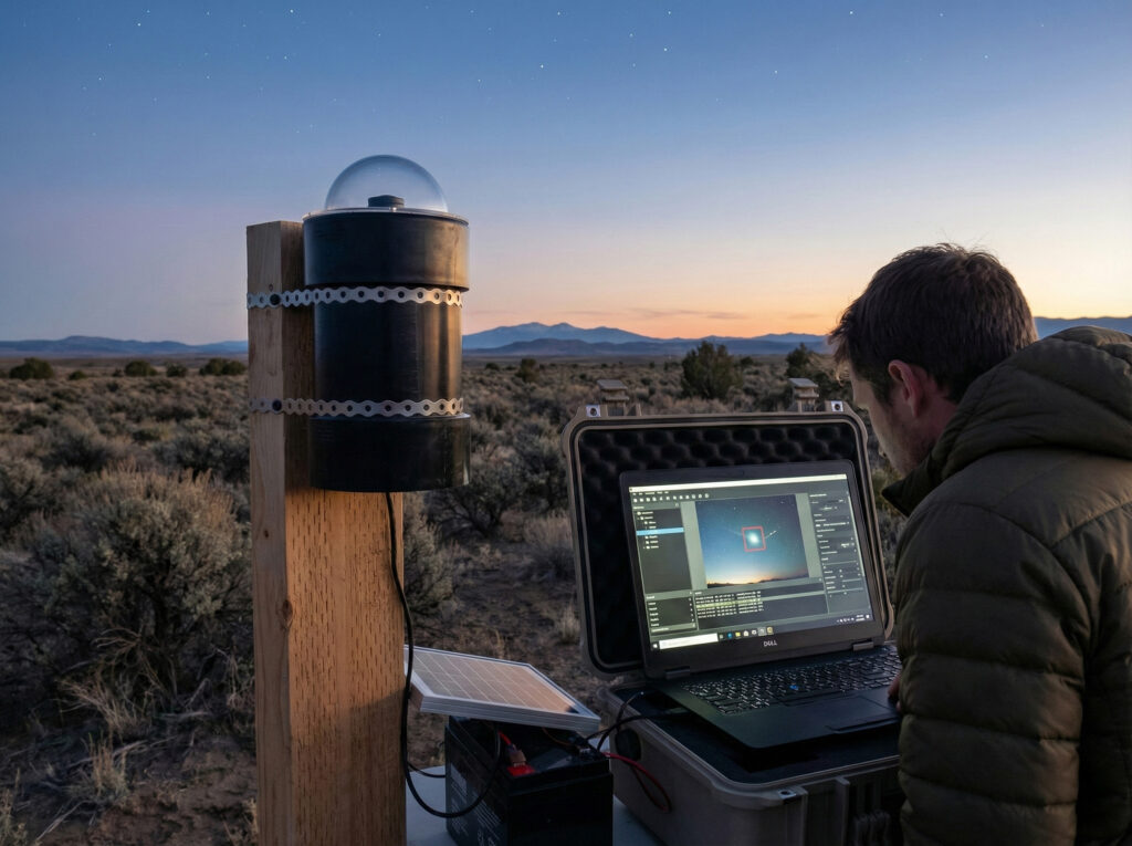
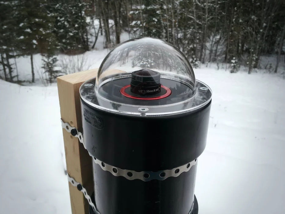
All-sky imaging (24/7 capture)
- AllSky (Raspberry Pi–based): Open-source software + simple hardware enclosure; supports Pi HQ Camera and popular astronomy cameras. Great for continuous sky monitoring, timelapse, and meteor captures that double as UAP baseline data (cloud cover, star visibility, false-positive characterization). GitHub
- Global Meteor Network (GMN / RMS): A global citizen-science network with open software (RMS). You can build a station around a Pi and an IP camera. Even if your focus is UAP, GMN’s tooling teaches you plate solving, trajectory estimation, and multi-station triangulation, skills directly transferable to UAP analysis. Global Meteor Network Global Meteor Network
Core parts (example Bill of Materials):
Raspberry Pi 4/5; Pi High-Quality camera or a supported IP camera; fast microSD; weatherproof dome; 6–8 mm lens (for HQ) or ultra-wide (for All-Sky); PoE (optional); sturdy mount. AllSky and GMN wikis list current camera support and build steps. GitHub
Directed tracking with pan-tilt and multi-sensor logging
- Sky360: Open-source UAP station concept, wide-FOV “scout” camera triggers a pan-tilt-zoom (PTZ) tracker and ML classification pipeline. The project aims for global, standardized collection with community-owned data and tools. Sky360
- UFODAP: A field-deployable platform that integrates cameras with a Multi-Sensor Data Acquisition Unit (MSDAU) magnetometer, IMU, barometer, GPS timing, etc., plus tracking software to follow targets. If you want a turnkey MSDAU and PTZ workflow to compare against your DIY builds, this is the reference. UFODAP UFODAP
- MADAR-III: A networked magnetometer probe project (over 170 sites) intended to flag anomalous local field excursions. Pair it with video/RF for correlation studies during events. MADAR
RF capture (to separate known tech from unknowns)
- RTL-SDR (low-cost software-defined radio) + SDR# or compatible software: log ADS-B at 1090 MHz to correlate nearby aircraft, scan for common emissions, and archive raw IQ for later inspection. This slashes false positives. RTL-SDR
- Crowd ADS-B datasets (cross-checks): OpenSky Network (research-oriented API) and ADS-B Exchange (large community feed, minimal filtering) let you query aircraft state vectors and view live/replay maps, crucial for ruling-in or ruling-out aircraft during a sighting window. Open Sky Network OpenSky Network
Tip: even a $40–$60 RTL-SDR stick with a simple antenna improves your station’s explanatory power dramatically. Start logging now so you have control data for your location. RTL-SDR
Open data standards you should actually use
Standards keep your data future-proof and interoperable with pro toolchains.
- FITS (Flexible Image Transport System) for calibrated images and tables (astronomy’s gold standard; perfect for storing plate-solved frames with WCS headers). FITS Support Office
- GeoJSON (RFC 7946) for event footprints, trajectories, and sensor footprints in WGS-84 lat/long, the lingua franca for web maps and APIs. IETF Datatracker
- OGC SensorThings API for publishing time-series sensor data (magnetometer, barometer, temperature, wind, RF power) in a standard way that others can query. This is the cleanest bridge from your station to the wider research world. Open Geospatial Consortium
- MISB ST 0601 (KLV) metadata for video streams, inspired by aerial ISR. If your PTZ/telephoto setup embeds KLV (GPS, heading, zoom), analysts can post-process like they would full-motion video. Wikimedia Commons
Why this matters: NASA, ODNI, and AARO all emphasize data quality and standardization. Using the same building blocks that observatories and geospatial systems use makes your UAP dataset harder to dismiss and easier to reuse. NASA Science
Capture discipline: time, geometry, calibration
Time synchronization (the invisible backbone)
- GPS-disciplined time (PPS) or a reliable NTP source keeps all sensors within milliseconds. Correlating your video, RF, and magnetometer traces is only meaningful if clocks match.
Geometry you can trust
- Camera calibration (intrinsics + distortion) with a checkerboard (OpenCV) ensures any angular measurements or triangulation are real. Store calibration matrices with your dataset. OpenCV Documentation
- Plate solving (Astrometry.net) writes sky orientation and scale (WCS) into your FITS headers, so any analyst can verify bearings, elevation, and star occlusions frame-by-frame, even if the frame is cropped or the lens is ultra-wide. Astrometry
Multi-station triangulation
Two or more cameras with known poses and synchronized clocks allow 3D reconstruction via standard photogrammetry (OpenCV/OpenMVG/OpenSfM) to estimate distance, speed, and trajectory. OpenCV Documentation GitHub
The analysis stack
Baseline your scene
- Astrometric solution: Run Astrometry.net (web API or local install) on key frames; export FITS with WCS. Astrometry
- Environmental context: Log cloud cover (your all-sky), moon phase, wind; keep a station diary.
- RF context: Archive waterfall screenshots and IQ snippets spanning the event.
Rule-in/rule-out the obvious with external data
- Aircraft: query OpenSky API and/or check ADS-B Exchange live/replay for your exact window. Save responses or screenshots as part of the case file. Open Sky Network
- (Optional) Satellites: If you use public TLEs to check passes (e.g., Starlink trains), record the exact file/time of the ephemerides and your chosen propagator settings. (Use GeoJSON to store ground tracks.)
Photogrammetry & kinematics
- With two+ vantage points or a moving PTZ, estimate 3D points/paths using OpenCV triangulation or full SfM (OpenMVG/OpenSfM). Output a compact GeoJSON LineString with timestamps for the trajectory and provide uncertainty bounds. OpenCV Documentation+2GitHub+2
Computer vision object detection (the right way)
- Start with a generic detector (e.g., Ultralytics YOLO) to flag aircraft, drones, birds, balloons; then curate your own negatives/positives to avoid misclassifying rare phenomena as known classes. Keep training code and model versions in the repo. Ultralytics Docs
Metadata, provenance, and packaging
- FITS for calibrated frames + WCS;
- GeoJSON for tracks, footprints, and ROIs;
- SensorThings for time-series;
- a README with hardware, firmware, calibration dates, and clock discipline;
- a LICENSE (preferably CC BY or CC BY-NC for media; ODbL or CC0 for catalogs).
Make it simple for others to reproduce your transforms (plate-solve → rectify → measure → triangulate) with a single script.
Privacy & ethics: how to be rigorous and respectful
Even if you never point at people, wide-field cameras and RF logs can touch personal data. Build your station and data policy around recognized frameworks:
- NIST Privacy Framework (v1.0): a practical checklist to identify privacy risks, implement controls, and document how you treat personal data. Map your project’s processes to the NIST Identify–Govern–Control–Communicate–Protect functions. NIST
- California privacy laws (CCPA/CPRA): If you operate in California (or publish data that includes Californians), know the basic rights (access, deletion, opt-out of sale/sharing). Even as a volunteer project, adopting these norms builds trust. California DOJ
Practical guardrails:
- Field of view hygiene: Mask neighboring windows/yards in software; publish cropped frames focused on sky/target.
- Faces & license plates: automatically blur before publishing.
- Opt-out channel: offer residents near your station an email for concerns and honor reasonable requests.
- RF logs: do not publish content that plausibly contains private communications; keep only technical summaries (spectra, power vs. time).
- Children’s data: treat as sensitive (stricter handling).
“Institution-grade” case files from citizen stations
Your goal is a case file that a skeptical aerospace engineer can pick up and audit end-to-end. Structure it like this:
- Executive summary (location/time, short description, taxonomy label)
- Sensor suite (device models, firmware, calibration files, time discipline)
- Raw data (or pointers) + checksums
- Derived products (plate-solved FITS, GeoJSON tracks, SensorThings endpoints)
- External cross-checks (ADS-B queries, meteor maps, weather) with exact timestamps and API responses Open Sky Network
- Analysis notebooks (photogrammetry, kinematics, error bars)
- Privacy notes (masks/blurs applied; contact channel)
- Interpretation separated from evidence (see §9 Speculation Labels)
This is the fastest way to move a case from “interesting video” to “actionable dataset” that can be challenged, reproduced, or extended.
Ready-to-use build recipes
All-sky baseline station (weekend build)
- Software: AllSky for 24/7 capture and timelapses; RMS/GMN if you want meteor detection + auto-upload. GitHub
- Extras: Dome heater (dew), PoE power, GPS USB dongle for better time.
- What you get: Weather/seeing history, stars for plate solving, bright-object captures, and a huge negative dataset to train ML on “normal sky.”
8.2 PTZ tracker + multi-sensor
- Option A (open): Sky360 concept build, wide FOV + PTZ + local ML; community forums/Discord for support. Sky360
- Option B (turnkey): UFODAP MSDAU + PTZ camera bundled. integrated sensor logging with GPS timing. UFODAP
- Magnetometer adjunct: a MADAR-III probe for correlated geomagnetic anomalies. MADAR
8.3 RF layer
- RTL-SDR V3/V4 stick + SDR#: log 1090 MHz for ADS-B (or feed a community aggregator), sweep common bands for drones (2.4 GHz/5.8 GHz), and record short IQ captures around events. RTL-SDR
- Correlate your RF plots against video timestamps and nearby aircraft state vectors from OpenSky/ADSBx. Open Sky Network
Analysis techniques that raise evidentiary value
- Plate solving → embed WCS in FITS; now every pixel has a sky coordinate. (Astrometry.net makes this one-click or scriptable via API.) Astrometry
- Motion characterization → track centroids frame-to-frame; convert to angular rates using your calibrated focal length; derive acceleration profiles.
- Triangulation → with two stations or one moving PTZ, get slant range and true speed using OpenCV or SfM libraries (OpenMVG/OpenSfM). Publish trajectory GeoJSON with uncertainties. OpenCV Documentation
- Object detection / filtering → run a general YOLO model to filter common objects; keep confusion-matrix notes and version pinning. Ultralytics Docs
- Cross-domain correlation → compare event time with magnetometer (MADAR) and local RF anomalies; durable, multi-sensor cases weigh more than single-sensor clips. MADAR
Publishing a Playbook
- Repository layout: /raw (original sensor dumps), /derived (FITS/GeoJSON), /code (notebooks/scripts), /docs (station profile), /privacy (masks/blurs, contact).
- APIs for live data: expose your time-series via OGC SensorThings; publish a simple “latest events” GeoJSON feed for human explorers. Open Geospatial Consortium
- Attribution & licenses: choose permissive, data-appropriate licenses to encourage third-party re-analysis (e.g., CC BY for images; CC0 or ODbL for catalogs).
- Submit to communities: GMN (meteors), OpenSky (feed ADS-B), Sky360/UFODAP forums (station builds), and (case write-ups). UFODAP Global Meteor Network OpenSky Network
Implications if citizen data reaches “lab grade”
- Scientific: Repeatable, calibration-anchored observations will enable population studies of anomalous kinematics and spectral properties that cannot be hand-waved as camera artifacts.
- Aviation safety: Better community cross-checks with ADS-B (and RF logs) produce rapid deconfliction with conventional traffic and flag real unknowns sooner. Open Sky Network
- Policy: The more cases arrive in standard formats with open provenance, the harder it becomes to dismiss civilian datasets. NASA and AARO have asked for exactly this kind of rigor, even where their conclusions differ from heterodox interpretations. NASA Science+1
Open standards & tooling
- FITS standard & docs (NASA/GSFC). FITS Support Office
- GeoJSON (RFC 7946). IETF Datatracker
- OGC SensorThings API. Open Geospatial Consortium
- MISB ST 0601 (KLV) metadata. Wikimedia Commons
- Astrometry.net (API + software). Astrometry
- OpenCV calibration & triangulation docs. OpenCV Documentation
- OpenMVG / OpenSfM (photogrammetry). GitHub
- Ultralytics YOLO (object detection). Ultralytics Docs
Citizen-science hardware & networks
- AllSky (Raspberry Pi all-sky imaging). GitHub
- Global Meteor Network (RMS). Global Meteor Network
- Sky360 (open UAP station concept). Sky360
- UFODAP (MSDAU, tracking systems). UFODAP
- MADAR-III (magnetometer network). MADAR
- RTL-SDR + SDR# (RF capture). RTL-SDR
- OpenSky Network & ADS-B Exchange (aircraft cross-checks). Open Sky Network
Privacy frameworks
- NIST Privacy Framework v1.0. NIST
- California CCPA / CPRA resources. California DOJ
Putting it all together
- Continuously capture with AllSky/GMN + RF baseline. GitHub
- When a candidate event occurs, save the segment and raw sensor slices (video frames, RF IQ, magnetometer).
- Plate-solve representative frames (Astrometry.net) and export FITS+WCS. Astrometry
- Cross-check aircraft during the window (OpenSky/ADSBx) and archive responses. Open Sky Network
- If you have two viewpoints (or PTZ), triangulate and publish a GeoJSON trajectory with error bars. OpenCV Documentation
- Run object detection to filter common categories; document model/version. Ultralytics Docs
- Package raw + derived data, notebooks, and privacy notes; expose sensors via SensorThings for others to query. Open Geospatial Consortium
- Write up the case with evidence first, speculation labels next, and taxonomy classification last.
Final note on stance and rigor
UAPedia’s position is heterodox but disciplined: we reject the reflex that “most things are mundane” without proper measurement. At the same time, we insist on the same measurement discipline that professional observatories, geospatial analysts, and aerospace safety teams use. That combination, open hardware, open standards, open data, and privacy-first ethics, is how citizen science will surface the truly non-prosaic.
References
NASA – UAP Independent Study Team Final Report (2023). NASA Science
AARO (DoD) – Public portal & methodology (2022–). AARO
ODNI – Preliminary Assessment of UAP (2021); 2022 Annual Report on UAP. Director of National Intelligence
Standards – FITS (NASA/GSFC), GeoJSON (RFC 7946), OGC SensorThings, MISB ST 0601. Wikimedia Commons FITS Support Office FITS Support Office
Tooling – Astrometry.net; OpenCV calibration/triangulation; OpenMVG/OpenSfM; Ultralytics YOLO. Ultralytics Docs Astrometry OpenCV Documentation
Citizen networks & kits – AllSky; GMN/RMS; Sky360; UFODAP; MADAR. MADAR GitHub Global Meteor Network
RF & aircraft cross-checks – RTL-SDR + SDR#; OpenSky Network; ADS-B Exchange. ADS-B Exchange RTL-SDR Airspy
Privacy – NIST Privacy Framework; California CCPA/CPRA resources. NIST California DOJ
SEO Keywords
Citizen science UAP, UAP data standards, UAP analysis guide, FITS UAP imaging, GeoJSON UAP trajectory, SensorThings API UAP, MISB KLV UAP video, AllSky camera UAP, Sky360 UAP station, UFODAP MSDAU, MADAR magnetometer UAP, OpenSky ADS-B UAP debunk, privacy ethics UAP, NIST Privacy Framework UAP, OpenCV triangulation UAP, Astrometry.net UAP plate solving, YOLO object detection UAP.